
Real-World Continuous Visual Datasets with Synchronized 6-DOF Telemetry for Autonomous Navigation
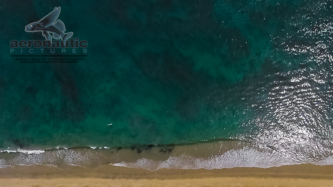
Continuous Aerial Nadir Datasets & Synchronized 6-DOF Telemetry for AI Navigation Training
High-Fidelity Optical Training Data for Vision-Based Navigation (VBN), Visual-Inertial Odometry (VIO), and GPS-Denied Systems Across Maritime, Terrestrial, and Aerial Domains.
The Physical Data Problem in Autonomous Navigation
Synthetic environments and generic commercial stock footage fail to meet the rigorous validation demands of mission-critical computer vision models.
Training reliable vision-based navigation (VBN), optical flow, and drift-estimation algorithms requires authentic physical physics: dynamic ocean swell behavior, variable sun glint, changing atmospheric optical density, and complex terrain textures. Furthermore, algorithms cannot be verified without high-accuracy, real-world ground truth.
Aeronautic Pictures provides continuous, uncut physical visual datasets specifically formatted for machine learning ingestion, paired with frame-synchronized vehicle position and attitude metadata.
Core Dataset Specifications
Datasets are captured as engineering assets and delivered in long-form blocks to client specifications, rather than segmented production clips (unless otherwise requested).
1. Optical Geometry & Perspectives
- True Nadir (90° Downward-Looking): Vertical-axis capture for any requirement, including groundspeed calculation, lateral drift estimation, visual odometry, and surface feature mapping.
- Forward & Oblique Angles: Fixed-pitch look-angles engineered for horizon tracking, surface obstacle detection, and forward velocity vectoring.
- Sensor Quality: High-bitrate, high dynamic range (HDR) capture at native 30+ fps to minimize motion blur, reduce rolling-shutter artifacts, and ensure micro-texture resolution across frames, or other specification as required by project, including 60, 120 and 240 fps.
2. Synchronized Ground-Truth Telemetry
To benchmark and validate neural network estimations, visual data is delivered with sensor platform metadata (options include embedded, sidecar, timecode-locked, etc.):
- Position: Multi-constellation GNSS / GPS data (Latitude, Longitude, Altitude, Velocity).
- Vehicle Attitude (Pose): 3-axis IMU telemetry recording instantaneous Pitch, Roll, and Heading/Yaw synchronized to recorded frames.
Operational Environments
Maritime & Open Ocean
The open ocean represents the most challenging environment for optical flow and visual navigation algorithms due to lack of static landmarks, dynamic wave-train motion, and intense solar reflection.
- Open Ocean & Swell Profiles: Continuous capture across varied Beaufort sea states, swell periods, and chop directions.
- Sun Angle & Glint Variation: Passes structured across direct overhead solar glare, diffuse overcast light, and low-angle golden-hour transitions to stress-test systems.
- Coastal & Shoreline Transitions: High-contrast land-to-water boundary transits for horizon-lock and shoreline-referencing models.
- Surface & Submerged Data: Mast height and underwater datasets to train autonomous navigation systems for UMV (Uncrewed Marine Vessel) surface and subsurface uncrewed platforms.
Terrestrial & Complex Terrain
For Terrain-Relative Navigation (TRN) in GPS-denied land environments:
- Feature-Sparse Environments: Arid desert, dry lake beds, and open plains designed to test edge-case performance where visual contrast is minimal.
- High-Relief Topography: Mountainous ridgelines, coastal ranges, and canyon terrain providing rapid altitude-delta transitions and deep shadow variations.
- Structured Infrastructure Grids: Agricultural patterns, rural road networks, and coastal infrastructure for landmark-referencing algorithms.
Multi-Domain Acquisition Platforms
We capture training data across three distinct operational regimes to match the specific physical dynamics of your target platform:
1. High-Altitude Crewed Fixed-Wing Operations (Beyond Part 107 Limits)
- Operational Regime: 90 to 140+ knots groundspeed; altitudes from 500 ft to 10,000+ ft AGL.
- The Regulatory & Physical Advantage: Eliminates the FAA Part 107 400-foot AGL ceiling restricting commercial drone operations. Enables legal, unrestricted high-altitude data capture over expansive terrestrial grids and deep open-ocean offshore airspace.
- Capabilities: Long continuous flight endurance, open-ocean offshore range, and large geographic flight availability.
- Use Cases: Training Vision-Based Navigation (VBN) and visual odometry for long-range autonomous aircraft, high-altitude UAS transit, and high-altitude GPS-denied navigation.
2. Uncrewed Fixed-Wing Systems (UAS)
- Operational Regime: Low-altitude tactical profiles; high Ground Sample Distance (GSD).
- Capabilities: Stable forward-flight aerodynamics with zero rotor downwash in the datasets, enabling clean visual surface capture at scale.
- Use Cases: Small-to-medium autonomous reconnaissance drones, low-level ingress platforms, and precision landing systems.
3. Stabilized Marine Mounts
- Operational Regime: 5 to 25 knots operational vessel speeds; positioned directly above the waterline, mast height, or UMV mast location.
- Capabilities: Bowsprit mounts to offshore power vessels, delivering pure forward translation over undisturbed ocean water with zero propeller spray or rotor wash artifacting; mast-mount systems capturing crewed or autonomous-appropriate clean data for GPS independent systems; submerged mounts offering required points of view tailored to submerged UMV (UUV/AUV) system specifications.
- Use Cases: Uncrewed Surface Vessels (USVs), autonomous maritime shipping, naval swarm craft, Uncrewed Underwater Vessels (UUV), Autonomous Underwater Vessel (AUV), and low-altitude sea-skimming autonomous systems.
Technical Heritage
Aeronautic Pictures brings foundational experience in spatial data acquisition for high-consequence visual simulation and defense applications (partial list of projects we are allowed to disclose):
- USAF MH-53J Special Operations Mission Rehearsal Systems: Captured systematic, overlapping medium-format film datasets for GE Aerospace’s state-of-the-art Compu-Scene image generation platform, providing the real-world visual foundation for the Air Force Special Operations Command (AFSOC) helicopter simulator at Kirtland AFB.
- Maritime Aerial Plates for Broadcast Television: Captured complex real-world Pacific Ocean aerial backgrounds and spatial tracking plates for the History Channel series Dogfights, accurately reproducing maritime aerial combat environments.
- High-Velocity Airframe Integration: Extensive history operating forward-looking systems on high-performance fixed-wing platforms, including nose-mounted Learjet aerial capture.
Data Delivery & Engagement Model
We deliver structured data assets under transparent R&D frameworks.
- Custom Data Acquisition Sorties: Dedicated flight and maritime collection missions staged from Southern California or nearly anywhere else on earth. Flight and maritime operations are conducted to customer-defined specifications, including coordinates, altitudes, look-angles, weather, and data requirements.
- Licensing Structure: Delivered under an Enterprise AI & Autonomous Navigation Training License. Aeronautic Pictures retains underlying copyright; your organization receives perpetual, worldwide rights for internal model training, algorithmic validation, and system R&D.
- Milestone Execution: Custom acquisition packages are structured around clear operational milestones (Specification Sign-Off / Mission Schedule / Final Data Verification).
Request Technical Specifications or Data Review
To discuss parameters for a dedicated data collection sortie, reach out to our team directly:
Aeronautic Pictures ContactE-mail: Contact Form
Inquiries typically receive a direct response within one business day.